|
|
Storm
Mountain News
|
|
Local News
|
|
Saturday
September 23rd - SMN Endorses Angie Paccione For
Congress...Storm Mountain
News announced today that they are officially
giving their endorsement to Angie
Paccione (D) for the 4th District of Colorado
seat, in the United States Congress.
"We are not in the
practice of endorsing political candidates and
this is the first time we have ever done so",
stated SMN owner Darrell Spangler. "It was
the unanimous agreement of our staff that this
endorsement was an exception. We strongly feel a
change is needed in Congress and that Paccione
offers the best ideas and direction for that
change and will better represent the values,
viewpoints and opinions of the People of Colorado
in Washington, D.C.."
This unusual decision to
endorse a political candidate was reportedly made
after reviewing the voting record of incumbent Marilyn
Musgrave (R), and the overall direction the
current administration is taking America.
Spangler added, "We
feel that Musgrave has failed to listen to her
constituents and instead voted lockstep with
George Bush throughout her past term, allowing him
to run shotgun over America and the world,
ignoring and violating both United States and
International law along the way. This is
unacceptable behavior for our leaders. Our hope is
that new faces and ideas in Washington will return
our great nation to its previously respected
status as a world leader and pioneer of the
future. The past six years have been some of
America's worst, with the blame lying squarely on
the current administration and the members of
Congress, like Musgrave, who supported them."
SMN has confirmed that their
publication will remain unaffiliated with any
political party and will continue to present views
and opinions, equally and impartially, from any
and all candidates. Darrell Spangler is officially
registered in Larimer County as
"Unaffiliated", as are the majority of
the SMN staff and associates.
|
|
Friday
September 22nd - Winter Storm Warning For
Mountains...
The National Weather
Service in Denver has issued a Winter
Storm Warning for the northern Colorado
mountains in effect through Saturday
morning.
A STORM SYSTEM WILL AFFECT
THE AREA THROUGH TONIGHT WITH PERIODS OF SNOW IN
THE MOUNTAINS. SNOW WILL BE HEAVY AT TIMES THIS
AFTERNOON INTO TONIGHT WITH TOTAL ACCUMULATIONS BY
SATURDAY MORNING OF 1 TO 2 FEET IN SOME PLACES.
NORTHWEST WINDS OF 20 TO 30 MPH WITH GUSTS TO 50
MPH WILL PRODUCE AREAS OF BLOWING SNOW AND POOR
VISIBILITIES OVER THE HIGHER MOUNTAIN PASSES. OVER
NORTHEAST COLORADO RAIN SHOWERS WILL BECOME LIKELY
BY LATE AFTERNOON AND CONTINUE INTO THE EARLY
EVENING HOURS BEFORE ENDING BY MID EVENING. SOME
OF THE RAIN MAY MIX WITH OR CHANGE TO SNOW ABOVE
5500 FEET THIS EVENING HOWEVER NO ACCUMULATIONS
ARE EXPECTED AT THIS TIME.
The complete text of this
official warning is available via the link provided
below.
Winter
Storm Warning
|
|
Thursday
September 21st - Winter Storm Watch Tonight Thru
Friday...
The National Weather Service
in Denver has issued a Winter Storm Watch for the
front range mountains and foothills in effect from
Thursday night through Friday night. The watch
area includes the Drake, Glen Haven and Storm
Mountain areas.
With the coming of Fall this
year, also comes our first winter storm watch of
the season:
A STRONG UPPER LEVEL LOW
PRESSURE SYSTEM WILL AFFECT THE COLORADO MOUNTAINS
TONIGHT. SCATTERED RAIN SHOWERS AND THUNDERSTORMS
WILL CHANGE TO SNOW THIS EVENING AS A SHARP COLD
FRONT MOVES ACROSS THE MOUNTAINS. THE SNOW MAY BE
HEAVY AT TIMES. ANOTHER SYSTEM WILL MOVE ACROSS
THE MOUNTAINS THURSDAY NIGHT THROUGH FRIDAY NIGHT
AND COULD PRODUCE HEAVY SNOWFALL IN THE MOUNTAINS
AND HIGHER FOOTHILLS.
WHILE A MIXTURE OF RAIN AND
SNOW IS EXPECTED IN THE FOOTHILLS TONIGHT, A
SECOND STORM SYSTEM WILL BRING COLDER TEMPERATURES
AND A CHANCE OF HEAVY SNOW TO THE FOOTHILLS
FRIDAY. THE AMOUNT OF SNOWFALL IS HEAVILY
DEPENDENT ON THE TRACK AND SPEED OF THE STORM
WHICH WILL DETERMINE THE AMOUNT OF UPSLOPE WINDS
AGAINST THE FOOTHILLS. SNOWFALL IN THE LOWER
FOOTHILLS WILL ALSO DEPEND ON THE TEMPERATURES
WHICH MAY BE TOO WARM TO ALLOW SNOW ACCUMULATION
DURING THE DAY ON FRIDAY. WHILE THIS MAY NOT BE A
MAJOR EVENT, THERE IS POTENTIAL FOR A LONG PERIOD
OF HEAVY UPSLOPE SNOWFALL FRIDAY AND FRIDAY NIGHT.
THIS COULD PRODUCE FROM 5 TO 15 INCHES OF SNOWFALL
IN THE FOOTHILLS. THE HEAVY SNOW IS MOST LIKELY AT
ELEVATIONS ABOVE 7500 FEET AND IN THE FOOTHILLS OF
BOULDER AND LARIMER COUNTIES.
The complete text of this
official watch is available via the link provided
below.
Winter
Storm Watch
|
|
Sunday
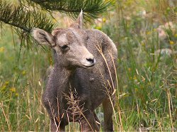
September 17th - Photo Of The Week...
This week's photo features a
young Bighorn Sheep standing along Highway 34, two
miles west of Drake, on last Sunday morning.
Along with other area
wildlife, Bighorn Sheep become more active during
the Fall, foraging on green plants in preparation
for the coming Winter, when food will be less
abundant.
Bighorn Sheep are most active
during dawn and dusk, but can be seen at most
anytime of the day or night along area roadsides.
If driving through our area at this time of year,
stay alert for Bighorn or other animals in the
roadway. A slower drive may reward you with a
priceless view of these wonderful creatures in
their natural habitat.
|
|
Saturday
September 16th - High Wind Warning Today...
The National Weather Service
in Denver has issued a High Wind Warning for the
majority of the front range mountains and
foothills, including the Drake, Glen Haven and
Storm Mountain areas, until 6:00PM MDT this
evening.
Gusty southwest winds across
the front range foothills and mountains are
expected to shift to the west and quickly increase
to 30-40mph. Peak gusts in wind prone areas could
reach 75-80mph.
Area residents are advised to
secure or move indoors any patio furniture, grills
and other objects subject to blowing away. Drivers
of high-profile vehicles should use caution when
driving or delay travel until this evening, as
very strong gusting is expected.
In addition to the high
winds, much cooler temperatures can be expected
for the next few days with nigh-time lows
approaching the freezing point in some areas.
Homeowners and gardeners should be prepared to
cover less hardy plants on these nights.
"HIGH
WIND WARNING"
|
|
Previous
Week |
|
|
|