__________________
Homeland Security
____________________
____________________


__________________
"The Storm Mountain Incident"
Pollution of our
National Forest Streams
(Requires
Free PowerPoint Viewer available here)
__________________

Contamination to Storm Mountain Properties
Click here for the facts!
__________________
__________________
![]()

![]()


__________________
![]()
__________________
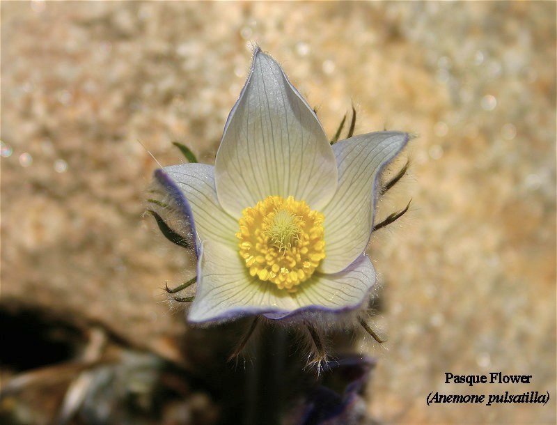
Sunday, April 10th - Photo Of The Week... While it may be hard to believe with today's weather, our local wildflowers have started blooming. As the Daffodils and Tulips usher in Spring in the valleys, Pasque flowers are the mountain's harbingers of Spring. This photo taken Thursday, April 7th shows an area Pasque Flower in full bloom. The Pasque Flower (Anemone pulsatilla) is one of the first flowers to bloom often coming up through the snow. Another interesting fact is that the Pasque Flower is one of few plants whose flowers precede it's leaves... The leaves traditionally appear after the plant's blooms have faded. |
|||
Saturday, April 9th - Winter Storm Warning In Effect For Tonight... The National Weather Service in Denver has upgraded the previous Winter Storm Watch to a Winter Storm Warning. This warning is for the northern front range foothills, including the Storm Mountain, Drake and Glen Haven areas and will be in effect from 9PM MDT tonight through 6PM MDT on Sunday. This is a WARNING and not a WATCH! SNOW ACCUMULATIONS OF 15 TO 30 INCHES ARE POSSIBLE IN THE FRONT RANGE FOOTHILLS, AND HIGHER EAST SLOPES OF THE MOUNTAINS. SNOW AMOUNTS WILL RANGE FROM 6 TO 15 INCHES IN SOUTH PARK. NORTH TO NORTHEAST WINDS OF 15 TO 30 MPH WITH GUSTS UP TO 45 MPH WILL CREATE AREAS OF BLOWING SNOW AND POOR VISIBILITIES. REMEMBER, A WINTER STORM WARNING MEANS SEVERE WINTER WEATHER CONDITIONS ARE IMMINENT OR HIGHLY LIKELY. Residents are advised to stay alert for rapidly deteriorating conditions tonight, and to be prepared for extremely difficult to impossible driving conditions by tomorrow morning. The complete text of this warning is available via the link provided below.
|
|||
Winter Storm Watch Remains In Effect For Saturday Evening... The National Weather Service in Denver is continuing a Winter Storm Watch for most of the northern Colorado mountains and foothills, including the Drake, Glen Haven and Storm Mountain areas in effect from Saturday evening through Sunday evening. RESIDENTS OF EASTERN COLORADO SHOULD NOT BE FOOLED BY THE RECENT MILD WEATHER THEY HAVE BEEN ENJOYING. A STRONG, LATE WINTER STORM FORMING OVER THE GREAT BASIN TODAY WILL MOVE OVER COLORADO TONIGHT AND SUNDAY, BRINGING A RETURN OF WINTRY PRECIPITATION, GUSTY WINDS AND MUCH COOLER TEMPERATURES. SOME AFTERNOON RAIN SHOWERS AND POSSIBLE THUNDERSTORMS ARE EXPECTED TODAY, MAINLY OVER THE MOUNTAINS AND FOOTHILLS. LATER TONIGHT, TEMPERATURES WILL FALL INTO THE 30S ON THE PLAINS WHILE RAIN OR SNOW BECOMES WIDESPREAD. BY SUNDAY MORNING, SNOW IS EXPECTED TO BE FALLING ACROSS NORTH CENTRAL AND NORTHEAST COLORADO. AS THE SNOW CONTINUES THROUGH SUNDAY, IT COULD BECOME HEAVY AT TIMES, ESPECIALLY IN AND NEAR THE FRONT RANGE FOOTHILLS. ALONG WITH THE SNOW, GUSTY WINDS MAY PRODUCE POOR VISIBILITIES AT TIMES DUE TO BLOWING AND DRIFTING SNOW. WIDESPREAD SNOW WILL DEVELOP THIS EVENING AND CONTINUE THROUGH SUNDAY. ISOLATED THUNDERSTORMS WILL ALSO PRODUCE VERY HEAVY LOCALIZED SNOW THIS EVENING. SNOW ACCUMULATIONS OF 15 TO 30 INCHES ARE POSSIBLE IN THE FRONT RANGE FOOTHILLS AND HIGHER EAST SLOPES OF THE MOUNTAINS. LESSER AMOUNTS OF 6 TO 12 INCHES ARE EXPECTED OVER THE MOUNTAIN VALLEYS. NORTHEAST WINDS OF 15 TO 30 MPH WILL ALSO CREATE AREAS OF BLOWING SNOW AND POOR VISIBILITIES. |
|||
Friday, April 8th - Winter Storm Watch Issued For Saturday Evening... The National Weather Service in Denver has issued a Winter Storm Watch for most of the northern Colorado mountains and foothills, including the Drake, Glen Haven and Storm Mountain areas in effect from Saturday evening through Sunday evening. A MAJOR SPRING STORM WILL TAKE SHAPE SATURDAY NIGHT AND SUNDAY AS LOW PRESSURE INTENSIFIES ALONG THE NEW MEXICO AND COLORADO BORDER. THIS STORM HAS THE POTENTIAL TO PRODUCE SIGNIFICANT SNOWFALL ACROSS THE FRONT RANGE FOOTHILLS, URBAN CORRIDOR, AND PALMER DIVIDE LATE SATURDAY NIGHT AND SUNDAY. AT THIS TIME THERE IS THE POTENTIAL FOR ONE TO TWO FEET OF SNOW IN THE FOOTHILLS, AND UP TO A FOOT OVER THE URBAN CORRIDOR, MAINLY FROM FORT COLLINS SOUTHWARD INTO DOUGLAS COUNTY. NORTH WINDS WILL ALSO INCREASE WITH GUSTS UP TO 35 MPH WITH BLOWING SNOW AND POOR VISIBILITIES EXPECTED. FURTHER EAST, THE RAIN WILL TURN OVER TO SNOW SUNDAY MORNING, SNOW AMOUNTS WILL BE A BIT MORE LIMITED. DEPENDING ON THE EXACT TRACK OF THE STORM, SNOW AMOUNTS COULD BE EVEN HIGHER THAN NOTED ABOVE. STAY TUNED FOR THE LATEST STATEMENTS ON THIS POTENTIALLY DANGEROUS LATE SEASON STORM. |
|||
Approaching Spring Weather System Targets Area... A large and powerful weather system is approaching our area from the west. This Spring system contains a high amount of moisture and is expected to produce a strong upslope flow with the potential of bringing snow in feet, not inches, to the mountains and foothills starting Saturday evening, and continuing through Sunday. Area residents are advised to be prepared for rapidly deteriorating conditions Saturday evening and to stay alert for watches, advisories, and/or warnings. There are currently no official watches or advisories in effect for our immediate area. |
|||
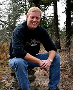
Thursday, April 7th - Local Photographer To Be Featured At New Restaurant... The photographic work of area resident, Darrell Spangler, is soon to be featured at the recently opened restaurant, "Cisco’s", near McDonald’s in Lower Stanley Village, in Estes Park. Prints of his photos, many of which have been published in the, "Estes Park News", will be on display starting next week, with residents and area visitors being able to purchase the prints right from the walls. All prints will be signed by Spangler, as well as being matted and framed. Spangler’s photos have also appeared on postcards for Rocky Mountain National Park, numerous media publications, and an "International Magazine Cover". Darrell was born and grew up in the Chicago area and moved to Estes Park in 1992. In 1999, he moved onto Storm Mountain in Drake, Colorado where he currently resides with his family. “Living where I do and being a photographer is truly a blessing” states Spangler, “I can think of no other area that presents so many wonderful, and almost daily, opportunities for photos anywhere.” Spangler’s other interests include web development, astronomy, local geology and mineralogy in which he is considered one of the most knowledgeable and experienced individuals in our area. |
|||
Wednesday, April 6th - Prescribed Burn At Horsetooth Mountain Park... On Thursday, April 7, Larimer County plans to conduct a prescribed fire on approximately 70 acres of the Hughey Open Space at Horsetooth Mountain Park. The burn area is located approximately five miles west of Fort Collins near Horsetooth Mountain. The prescribed fire will take place only if weather and safety conditions allow. Smoke will be visible from I-25 and as far away as Denver International Airport on the day of the burn and potentially for a couple days afterwards. The project is being implemented in cooperation with the Colorado State Forest Service, Larimer County Parks and Open Lands, Larimer County Wildfire Safety Program, Larimer County Sheriff’s Office Emergency Services and the U.S. Forest Service. The fire will be carried out in accordance with a burn permit and will help to accomplish the goals of the Horsetooth Mountain Park Forest Stewardship Plan. The goals of the Forest Stewardship Plan are to:
Do not call 911 if you see smoke! For information and updates at any time, please call our 24-hour hotline at (970) 498-1030 or (970) 498-1031. You can also check out www.larimer.org/emergency. |
|||
Tuesday, April 5th - Winter Weather Advisory Cancelled... The National Weather Service in Denver has cancelled a Winter Storm Advisory for our area, previously in effect until 4PM MDT. The brunt of the storm has taken a more southern path leaving our immediate area free of any winter weather threat. As of 11AM MDT, there are no watches, warnings, or advisories currently in effect for our area. |
|||
Monday, April 4th - Winter Weather Advisory For Tuesday... The National Weather Service in Denver has extended a "Winter Weather Advisory" to include the Glen Haven, Drake and Storm Mountain areas, in effect from 12AM MDT to 4PM MDT Tuesday. AN EARLY SPRING STORM WILL SLAM NORTH CENTRAL COLORADO TONIGHT AND TUESDAY, AND NORTHEAST COLORADO TUESDAY AND TUESDAY NIGHT. A NUMBER OF WARNINGS AND ADVISORIES HAVE BEEN ISSUED ACROSS NORTH CENTRAL AND NORTHEAST COLORADO BEGINNING TONIGHT. A STRONG SPRING STORM WILL MOVE ACROSS THE STATE, PRODUCING VERY STRONG WINDS, SNOW IN THE MOUNTAINS, AND A MIXTURE OF RAIN AND SNOW ON THE PLAINS. OVER NORTHEAST COLORADO, THE CRITICAL QUESTION WILL BE THE TEMPERATURE. HIGHER ELEVATIONS SUCH AS THE PALMER DIVIDE WILL BE COLD ENOUGH TO ACCUMULATE SNOW, WHICH WILL COMBINE WITH BRISK NORTHERLY WINDS TO PRODUCE BLIZZARD CONDITIONS BEGINNING LATE TONIGHT AND CONTINUING THROUGH TUESDAY. NEAR THE FOOTHILLS IN BOULDER AND DENVER SNOW WILL FALL EARLY TUESDAY, MIXING WITH RAIN LATER IN THE MORNING, BUT 2 TO 6 INCHES OF SNOW WILL BE POSSIBLE BY NOON TUESDAY. ELSEWHERE IN NORTHEAST COLORADO IT WILL BE TOO WARM FOR SNOW, BUT WIND WILL BE THE BIG PROBLEM TUESDAY AND TUESDAY NIGHT. IN THE MOUNTAINS, SNOWFALL AMOUNTS WILL RANGE FROM 4 TO 10 INCHES WITH LOCALLY HIGHER AMOUNTS POSSIBLE. GUSTY NORTHWEST WINDS WILL PRODUCE AREAS OF BLOWING AND DRIFTING SNOW OVER THE HIGHER PASSES. A WINTER WEATHER ADVISORY MEANS THAT A COMBINATION OF SNOW, WIND AND COLD TEMPERATURES WILL CREATE DIFFICULT TRAVEL CONDITIONS. SNOW WILL BECOME HEAVY AT TIMES LATER TONIGHT AND CONTINUE INTO TUESDAY AFTERNOON. ACCUMULATIONS OF 3 TO 6 INCHES ARE POSSIBLE COMBINING WITH BLOWING SNOW TO PRODUCE VISIBILITIES NEAR ZERO. The High Wind Watch that was previously in effect for our area has been cancelled.
|
|||
High Wind Watch Issued For Tuesday... The National Weather Service in Denver has issued a "High Wind Watch" for the majority of northern Colorado east of the Continental Divide, including the Glen Haven, Drake and Storm Mountain areas, for Tuesday, April 5th. A STRONG LOW PRESSURE SYSTEM IS EXPECTED TO DEVELOP OVER WESTERN KANSAS ON TUESDAY. NORTH TO NORTHWEST WINDS WILL SPREAD INTO EASTERN COLORADO EARLY TUESDAY AND INTENSIFY DURING THE DAY. RAIN SHOWERS AND SNOW SHOWERS WILL ALSO DEVELOP OVER THE PLAINS WITH THE SNOW LEVEL AROUND 5000 FEET. AT HIGHER ELEVATIONS, MAINLY FROM LIMON AND BYERS INTO ELBERT COUNTY, PRECIPITATION MAY OCCUR AS ALL SNOW AND COMBINED WITH THE WINDS MAY CREATE BLIZZARD CONDITIONS AT TIMES THROUGH TUESDAY AFTERNOON. NORTH TO NORTHWEST WINDS WILL INCREASE RAPIDLY TUESDAY MORNING. SUSTAINED WIND SPEEDS OF 50 MPH WITH GUSTS TO 70 MPH ARE POSSIBLE. THE WINDS WILL SLOWLY DECREASE TUESDAY EVENING. THE AREA FROM LIMON TO BYERS AND SOUTH INTO ELBERT COUNTY MAY ALSO RECEIVE SNOW WHICH WOULD CAUSE BLIZZARD CONDITIONS TO DEVELOP. This watch has been cancelled. |
|||
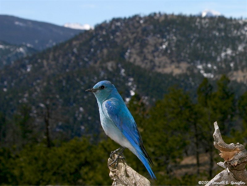
Sunday, April 3rd - Photo Of The Week... In staying with the theme of last week's photo of a female Mountain Bluebird, this week's photo features the male of the species. Brilliantly colored, the male Mountain Bluebird is one of the most beautiful birds in our area. His bright blue being unmistakable when seen flying through the area forests and fields. Bluebird numbers have increased in our area over the past couple of years, mainly due to the ideal habitat left behind by the, "Bobcat Gulch Wildfire", of 2000.
|
|||
Saturday, April 2nd - Spring Forward Tonight... Yes, it is once again that time of year when area residents will set their clocks ahead one hour, bringing us into Daylight Saving Time... This bi-annual change of our clocks was first used in 1883 by railroads, and first suggested by Benjamin Franklin in 1784. In 1884 a system of international time was adopted and is still in use today. The initial basis for these changes was to save energy. The, "Uniform Time Act of 1966", unified the dates of these changes to be the 1st Sunday in April, and the Last Sunday in October. Daylight Saving Time will begin at 2:00AM local time tonight. Residents are advised to set their clocks ahead one hour before retiring this evening. More information regarding Daylight Saving Time can be found via the link provided below.
|
|||
Friday, April 1st - Northern Colorado Calling Area Expanded... Long distance fees for telephone calls between most northern Colorado towns will disappear before year’s end. The Colorado Public Utility Commission (PUC) has approved a major expansion of the local calling area that will allow callers in Loveland, Fort Collins, Greeley, Windsor, Estes Park, Johnstown and neighboring towns to phone each other without any long distance tolls. The expansion comes as the result of cooperation between the communities’ officials and Qwest telephone company. “Residents and businesses throughout northern Colorado will all benefit from the elimination of toll calls due to the enlarged local calling area,” said Loveland Assistant City Manager Renee Wheeler. “This is an excellent example of several communities working together in support of an effort that benefits the entire region.” The expansion of the local calling area was requested because of the interdependency of northern Colorado for housing, employment, shopping, education, recreation, and social services. The expansion request stated calls should therefore be considered local, not long distance. The long distance fees are planned to end by December 1, by which time Qwest expects to have its computer changes completed. A map of the new calling area is available below.
|
|||
Fools In Love Extravaganza
Tomorrow... The
Estes Park area, has established such a great reputation as a
unique and beautiful location that couples are also now making
it their destination of choice, for fun and romance.
|
)
Disclaimer: Stories and other content are submitted by independent sources and do not represent the opinions or views of Storm Mountain Net, nor it's employees... All stories are posted without bias to their content... While every attempt is made to be concise in our reporting, Storm Mountain Net is not responsible for any incorrect information...